
FPOSM: the federation of OpenStreetMap pros
Sommaire
- 1 FPOSM: the federation of OpenStreetMap pros
- 2 Presentation of the guests
- 3 Presentation of the FPOSM
- 4 The stages of the effective creation of the association
- 5 The impact of the Digital Republic Act on open data
- 6 The governance of the association
- 7 The actions of the federation
- 8 State of the map 2026 in Paris
- 9 The federation’s advocacy actions
- 10 Collaboration and coopetition within the federation
- 11 The challenges of the federation in the months and years to come
- 12 Conclusion
- 13 Episode production
- 14 License
Walid: Hello and welcome to Projets Libres, LinuxFr.org’s podcast about free software, digital commons and open data. Welcome everyone, today we’re going to talk about OpenStreetMap a second time. I invite you, if you haven’t already listened to it, to listen to the first introductory episode, episode number 6 of season 3, introductory to OpenStreetMap. And today we’re going to talk with my two guests from the Federation of OpenStreetMap Professionals [FPOSM]. So I’m very happy because today I have two guests: Marina Petkova who is a founding partner of the company Dynartio and Florian Lainez who is a founding partner of the company Jungle Bus and president of the Federation of OpenStreetMap Professionals. Marina, Florian, welcome to the Projets Libres podcast! I hope you are doing well on the afternoon of March 9. Great,
Marina: Thank you very much for welcoming us, we are great.
Presentation of the guests
Walid: Perfect, let’s start, I’m going to ask you to start by introducing yourself please: who you are and how you discovered the digital commons and free software. Marina, do you want to start, please?
Marina: Marina Petkova, I am the manager of the company Dynartio and I am a member of the OpenStreetMap federation of pros. Maybe to tell you how I discovered the digital commons, the free software of OpenStreetMap: I’m the daughter of a developer and I grew up with free software, but without really asking myself any questions, without really understanding all the values and interests. And it was only much later, when I studied ecological transition law, that it naturally led me to the free and commons.
To tell the truth, when we talk about territorial planning and the ecological transition of our territories, we have major challenges in the co-construction of knowledge that is useful for the territories and for the various stakeholders. And that’s typically something that can’t be done with the owner. We need commons, we need to work together. And very often, we need OpenStreetMap. So, that’s how I fell into the digital commons and free software.
Marina Petkova
Walid: When did you discover OpenStreetMap? A long time ago?
Marina: I discovered OpenStreetMap in 2016, during a mapping party. And for the record, I didn’t get hooked at all in 2016. It wasn’t my hobby at the time. And then it was my colleague and the work that led me to do it professionally. What started as a pro assignment has now become a passion and I contribute to it every day in my spare time.
Walid: Great. Florian, on your side, who are you?
Florian: Yes, I fell into free software when I was little, I fell into the army when I was little, I have always been a free software player at heart. I did an internship at Mozilla, I was involved in the Wikimedia community. I looked at what was being done a little bit because I’ve never been a developer, so I had a bit of this impostor syndrome in this free software community.
And then OpenStreetMap is a project where you can go into the field, create geographical data, create maps, move around the world and create data that is useful to everyone, so I liked it right away and then the rest was a hellish spiral where I spent more and more time in the project. So I took on various responsibilities in OpenStreetMap, in a lot of projects and there to the point of proposing to all these companies to set up this federation of pros.
Walid: In which year did you find out about OpenStreetMap? In what way?
Florian: OpenStreetMap was created in 2004, I think I started in 2008 or 2009 if I remember correctly.
Walid: Very good. Do you want to explain quickly what you do professionally? Marina, what do you do at Dynartio?
Marina: In Dynartio, we are interested in issues of territorial planning and the circular economy. Overall, we have three areas of work. We carry out studies of what is called territorial metabolism, which means that we are interested in the flows and resources that are mobilised in a territory so that it can function properly. So, we’re going to talk about energy, matter, waste, carbon. Then, we are also developing open source tools dedicated to this flow analysis and we are deploying territorial observatories for the co-construction of territorial information. And then, of course, we contribute and use OpenStreetMap data related to these different topics.
Walid: Okay. And you, Florian at Jungle Bus?
Florian: On the Jungle Bus side, we are a bit of a special company because we were basically an association, we started mapping mobility in OpenStreetMap for fun in the evenings and on weekends. My partner and I are former SNCF employees and we created mobility data for work. We said to ourselves “no, but wait, we really need to map the bus network in detail for the whole of Île-de-France because otherwise life wouldn’t be fun”. We started to do that and then there were some people who were interested, we created an association and then we realized that there was a real need for companies and communities to be supported and really that there was a skill, that there was an expertise that they don’t have in-house to map mobility data in OpenStreetMap. Today, that’s what we’re doing. We do mobility in the broad sense. It’s rail networks with the interior of Île-de-France stations, for example. We also do mapping on the sidewalks for accessibility or networks.
Presentation of the FPOSM
Walid: Very good. I’m not going to start talking about that. It’s not the subject of the day, even if there’s no lack of desire. So, let’s move on to the first big part. We talked about the federation of OSM pros. I mentioned this in the introduction. This is the subject of today’s episode. Can you start by explaining what the OpenStreetMap federation of professionals is? Florian, do you want to start?
Florian:
The FPOSM, the Federation of Pros, is a group of companies that share the same values and that use OSM in their projects. That’s the subtitle of our federation. In fact, we started from the principle that in order to grow and support the digital commons that is OpenStreetMap, it was interesting to have companies that share the same values, that really have this sense of commonality. And that’s not really the case for all companies. We have companies that don’t play the common game.
Florian Lainez
And we said to ourselves, we are getting together between companies that are playing the game, that want to grow the OpenStreetMap project and we are trying to organize ourselves to grow this whole group of companies. At the beginning, there were less than 10 of us. And now, 4 years later, we are 26 companies.
Walid: How did it start? I mean, what is a bit of a trigger that made you start thinking about this federation?
Florian: So, there were quite old thoughts about grouping the answers to the people who make professional requests to us. Because on the side of the OpenStreetMap France association, which is the non-profit association, which only brings together individuals, there was already this bias for many years to never respond with services. So the OpenStreetMap France association does not provide any services and they had a lot of incoming requests to be professionally accompanied. And so, there was really a market and something that was interesting to manage on that side. We were very disappointed in the OpenStreetMap community to have to respond to someone who comes to ask for a service: “You just have to read the wiki, don’t worry, there’s the documentation, everything will be fine.” No, no, no, the communities, the companies, they really expect much more than that. And it is from this reflection that the Fed was born.
Walid: So first question, when do these reflections begin? And second question, at that time, if I am a local authority and I want to have a service around OpenStreetMap, what choice did I have?
Florian: Yes, so local authorities have been working with software services companies that have open source expertise and others that have open data expertise for many years. So, there were still solutions that already existed and then each of the companies, on our side we provided answers to our customers in our own sectors with Jungle Bus for mobility and then the other companies, each one in their own sector of activity. So, it was already existing.
Really, the federation allows us to group our efforts and so, there have been reflections, especially during the State of the Map France. The State of the Map is the annual event that brings together OpenStreetMap contributors for a weekend, for workshops, demonstrations, conferences. And it was during this State of the Map France that we consolidated, year after year, this reflection to create the federation.
Walid: It took several years. In what year was the association created? And you’ve started chatting quite a bit in previous years every time you see each other.
Florian: Yes, so it’s 2026. The federation’s statutes were filed in 2022, so it is celebrating its fourth anniversary, but we had been thinking about this project for maybe six, seven years, maybe even eight years.
Walid: Oh yes, it’s a long process.
Florian: It’s a long process because in the OpenStreetMap community, there are divergent branches of opinion on what needs to be done.
We had a lot of technical projects, technical collaborations or data creation. Here, the fact of organizing oneself into a sector is really something that is new, that is innovative and that does not exist throughout the world. In France, we are the only country to have a federation of professionals that is officially recognized by the OpenStreetMap Foundation , which is still a third entity. I hope I don’t use a lot of jargon, but there is the OpenStreetMap foundation which is global and which organizes the project. There is the OpenStreetMap France association which manages a little bit of volunteers on French territory and which is recognized as a chapter, therefore as an official organization by the Foundation. And then there is the Federation of Pros, which is the only entity whose members are professionals and which is also recognized by the Foundation. And that’s something that’s totally unheard of in the whole world.
Florian Lainez
Walid: Marina, when do you hear about the Federation? You weren’t one of the founding members, were you?
Marina: No, but from what I remember, we had heard about it at the time of its creation and it was founding members who allowed us to join the federation. And we, at that time, were rather young in our thinking about OpenStreetMap. We did it, but it wasn’t our core business. And the funny thing is that today, it is also thanks to the federation and thanks to the various colleagues we have been able to meet, that OpenStreetMap is taking an increasingly important place in our professional activity.
Walid: OK. We’ll come back to that in a game later. What is the legal status of the federation?
Florian: It’s a non-profit association, law 1901.
Walid: Was it obvious to everyone that we had to form an association or did you discuss the different possible statuses for this federation?
Florian: We discussed a lot of options, including cooperatives. And finally, it was the association that emerged. This reflection is really something that is still relevant in the federation, to think about the status and how we organize ourselves, not only in the federation, but also which companies are part of it and how we organize ourselves. Governance in open source is a subject that is never closed.
Walid: Listeners hear about it in almost every episode… OK, so association law 1901. What are the values you promote through the association?
Florian: The association aims to defend the OpenStreetMap project with its bases, its values as it is. So, it’s open source, open data and community functioning. So, I’m going to come back to these three points a little bit. These are really the three pillars of OpenStreetMap and therefore of the federation.
Open source is the use of software that is open and can be used by everyone. This is something in the OpenStreetMap community that is widely shared: not all software is open source to make OpenStreetMap, but nevertheless there is still a technical ecosystem that is extremely large and allows you to share code.
Open data is quite obvious: all the data in OpenStreetMap is open data, anyone can use OpenStreetMap data very freely under an open data license.
Community functioning is also something that is not easy in the business world and that for us, associations, companies that are part of the Federation of Pros, this mode of organization suits us well. We try to promote it, the collaboration of companies as such to create a community, to be part of the OpenStreetMap community, but to be a sub-community of companies that brings this common to life. For us, that’s really important.
Walid: As an association, do you have a charter?
Florian: Yes, the ethical charter is the document that was the most important and that we developed at the beginning. We did it before we created our statutes, it was the thing that seemed most important to us to distinguish ourselves from all these companies that make OSM because it’s written in the calls for tenders, because it’s fashionable or for reasons that can be quite valid. But we go beyond that, we say to ourselves, the actions of companies must strengthen the common, strengthen open source.
Walid: To finish on this part of the presentation, we can see that already both of you work around the microphone in different fields, the members of the federation work in very distinct fields, they are different profiles, what will we find as a professional society? In what field?
Marina: That’s also the value, the strength of the federation, is that our members have a wide, wide spectrum of skills and fields of activity.
We see a little bit of all types of activity that we can have around OpenStreetMap and I’m going to mention a few of them. There are members who do animation and mediation, organization of mapping parties for example, training of volunteer or professional contributors or agents in the communities. Photomapping and drone mapping, which we will then use in OpenStreetMap. We have members who are active in geomatics and geographic information systems. And then, members too who will do software development or consulting around free software. We also have design offices that will work on various subjects of the ecological transition and the place of data in the ecological transition. And then, everything related to logistics, mobility, active mobility, accessibility, route calculation. Here too, we have members who do that. And then, of course, cartographic service and map creation. So, really, from A to Z, we have skills from our members that will sweep the different applications of OpenStreetMap widely.
Marina Petkova
Walid : We’ll come back to this, but we can see that already, indeed, it can create synergies to respond to calls for tenders between the different members of the federation. If we go into a little more detail in the history of the federation, then what you were saying, Florian, is that it was years of discussion to get organized, to create this federation. What I would like to understand is the state of mind and what you went through in terms of discussions with the different members to arrive at this format.
Florian : So, at the beginning, there is already this idea of working better together. Companies working in OpenStreetMap, how do we work better together? It’s really very simple. I would almost say selfish. It’s really how we can do more business and do it better. So, indeed, there is a need to respond together to larger calls for tenders, to meet the needs of external entities, therefore private or public, which come to us to ask for services. And these services were getting bigger and bigger.
We can see that today, the largest cities in France are happily using OpenStreetMap in their creation of maps and digital services. This was not the case 10 years ago. So, it went up a little gradually. And then, there was also a movement that we watched from afar with a certain mistrust and also hope.
It is that of the large companies, especially American, which have contributed enormously to OpenStreetMap, more or less wisely. We had some fears. There are a lot of players, including Microsoft, Meta, AWS (so it’s Amazon), Apple, Mapbox, so in fact, it’s all the GAFAMs, minus Google. They have ganged up a bit, precisely, against Google, Google which has a considerable lead with its Google Maps, to create a foundation called Overture Maps, which is based on different sources of data, but in particular and mainly, firstly, OpenStreetMap, and whose governance they do not share. So they came out of OpenStreetMap at the top, that is, we take the data and we emancipate ourselves from governance, we emancipate ourselves from the community, and we do what we want.
Florian Lainez
So, it’s a double-edged sword. The community is very divided on Overture Maps. We saw it as a danger and it happened just when we were starting to structure our thinking and we said to ourselves: “there should be companies that start from the community and go to OpenStreetMap rather than the other way around”. And that’s really what we’ve been trying to do and what we’re trying to do today.
Walid : I come back to the local authorities that issue calls for tenders. Can you give examples for people like me who are not professionals in the sector? What type of call for tenders will we find? You were talking about big calls for tenders, what form can it take in fact? What would it be to do?
Florian : Then it’s extremely varied. I can already talk about my field of activity personally, the one I know, so it’s on mobility, so we’re former SNCF employees, so there’s still work in progress with SNCF Transilien to map and keep the mapping on the 380 stations in Île-de-France up to date, it also concerns the 6 major Parisian stations, That means mapping very precisely all the rooms, all the rooms inside all these stations. So, it’s really a monster job. And then there are other calls for tenders that concern the realization of a PAV, for example, the road development plan. So, it’s about determining where people with disabilities can or can’t go, what they can or can’t access.
With the Ministry of Transport, there are many calls for tenders on this subject. It can also be the work we do for Île-de-France Mobilités (which is the organising authority for transport in Île-de-France. Before, it was called the STIF), they are the ones who really organize the 60 carriers in Île-de-France, who organize the entire bus network in particular. And so with them, we work on data, on data to create local plans, the 40,000 local plans that everyone can see in the street on bus shelters, directly at the stopping points. So the answer to how do we create 40,000 proximity plans? In fact, we use the data in OpenStreetMap because it works and above all because it is really a technical solution that is very suitable for this kind of problem.
Walid : Marina, do you also want to highlight one or two examples?
Marina : The markets I saw were very much about cycling infrastructure, for example, or walkable infrastructure. I have seen several major contracts for the evaluation of the cycling master plan at the level of a department or at the level of a region where OpenStreetMap was very clearly visible in the technical specifications. That being said, in the markets that I do most often, it’s not always on the theme of mobility, but for example on the theme of food or waste, we don’t talk about OpenStreetMap in the technical specifications. Generally, when we respond to this contract, we are the ones who will bring OpenStreetMap back and who will argue why it is the right choice to recover, for example, the points of interest.
When we talk about food, we’re going to be interested in all the … Where are our farmers located? Where are the farm sales? The markets? There you go. As we work on flows, we will inevitably be interested first: where the actors are so that we can model the flows between actors. And for this, almost always, our first step of work is OpenStreetMap. And what’s interesting and a little sad is that in the markets, we don’t see it. The principals, in fact, they are not necessarily going to talk about OpenStreetMap, whereas for us, it is really the basis of the beginning of the work.
Walid : One of the ideas that led to the creation of the federation is this fairly usual pattern of the GAFAMs to take something, to try to take a common or something that there is, to try to get out of it and then do what they want with it. Earlier, Florian, you talked about service companies, companies that were quite big, that also did service. I think there were already some at the time who were performing.
Florian : Yes, there are some of them among our members. We can mention in particular Makina Corpus , which has been working in free and open data for many years, Latitude Cartagène, which makes proximity plans and is based in Lyon. There are many members in the Federation who have existed for a long time and who existed before OpenStreetMap.
The stages of the effective creation of the association
Walid : So you discuss and you arrive at the format of the creation of the association. What are the steps that lead to the effective creation of the association? First of all, first of all, this discussion is rather, if I understand, Franco-French at the moment. At the time you are making these reflections, have you already started to exchange with the OpenStreetMap Foundation? What is the relationship you have with the OpenStreetMap project itself and not only with the French association?
Florian : Yes, so the foundation, they already had this vision of the problems with the big IT companies, which is a bit of a double-edged sword. I’m not going to put them out of the community because there are some of them who have brought a lot to the community. Meta’s Map with AI project (to Facebook), Bing Maps, is Microsoft’s mapping, it uses OpenStreetMap. So, I don’t want to demonize them, not at all. It’s big companies that make and use OpenStreetMap because they need it. But we really wanted to do something else, to leave the community. So, I forgot the question.
Walid : My question was when did you start talking about it with the OpenStreetMap Foundation?
Florian : We talked about it with the foundation from the beginning, very quickly, when we had the idea, we said to ourselves: “it’s very important that the Foundation officially recognizes us”. We wrote the statutes, we sent them, and it took a little time, but they accepted the fact that they recognized us as official chapters . So, it’s very unprecedented. In France, there are two chapters that are officially recognized: the OpenStreetMap France Association and the Federation of Pros. And so, for us, it was important to push the fact that there is a new status that exists, in fact, with the Foundation, with companies only as members. And so, since then, they have renewed their confidence each time. They officially authorize us to use the OpenStreetMap brand.
Walid : OK. And so, the association, it’s created in 2022, right?
Florian : That’s right. It was created in 2022 after reflection. It was in 2017 that we started thinking. When we did a State of the Map France (it was in Nantes in 2022), we created the statutes. And then, since then, we have been carrying out our activities. And we are open to new memberships. These are companies that join us because they share our values and our objects.
Walid : At the time of this reflection, did you draw inspiration from other professional associations, either in the field of the commons, well, not necessarily in the field of carding, but did you have any sources of inspiration at the time of the creation of the federation?
Florian : So, in free software, there are a lot of models that we can look at. There is WordPress.com (it’s not WordPress.org, it’s a company that provides services based on the free software WordPress). For example, we have Mozilla Corp which is in parallel with the Mozilla Foundation. And then on Wikimedia, we also had a difficult relationship with companies, which are often companies that will try to influence articles on Wikipedia. So a very difficult relationship on the Wikimedia side where there are not really things that are similar. We were inspired by all these examples, other examples, and we created our own path. It is really a chapter recognized by the Foundation, which brings together companies. To my knowledge, in the major digital commons, this is not really something that is done directly. So, we had to create from that.
Walid : Are all these discussions done in an open way, for example on the forum, etc., or what was the organization in relation to the community? Is it something that was well regarded or not? Did you have any reluctance? How did it go at the time?
Florian : So,
OpenStreetMap has been open to contributions, especially from companies, since the beginning, since always. Nevertheless, there is still a branch that is very conservative, I want to say, in OpenStreetMap, of people who doubted a little bit about the positive impact of companies in general in OpenStreetMap. Creating the Federation was also already a message that said: “no, no, it’s possible, we are companies, we are for-profit and we are a positive force for OpenStreetMap”. So that was important for us to proclaim. Then, with the OpenStreetMap France association, we made them read our statutes and we still worked this subject from the beginning. And then, it must be said, of the founding members, in fact, the majority were part of OpenStreetMap France, its board of directors.
Florian Lainez
So, that’s really something. We are members of the volunteer community at the beginning and we created this structure on top of it. So, it’s really something that we did by constantly discussing with the community, with their agreement. Now, that being said, we have a principle in the Federation of Pros, which is that we have a forum, but it is internal, it is not open to the public, it is really reserved for its members. That way, it also attracts new companies to come and discuss our calls for tenders, our news, our problems that we have internally. It’s also a way to protect business law, because for us, when we discuss our contracts, it’s really important that we have confidence in the discussion when we talk to each other. And then, it’s a place where we prepare public responses, public documents, position papers and then responses to calls for tenders before making them in public.
Walid : When you announce the federation of OSM pros, are there other people in other countries who find the initiative interesting, who ask you questions and everything?
Florian : The main reaction we had was that of the foundation. At the international forum, we talked about it, we had few reactions. The foundation was very supportive of us being created. It really gave us a boost. They told us: “come, you absolutely have to do this”. So far, it’s something that we haven’t managed to develop to the end. Replicate this model in other countries… For the moment, there are not really any other countries that have seemed interested.
Governance in other countries is very different from that in France. I think in France that the OpenStreetMap France chapter , the non-profit association, from the beginning, they said that we don’t do services. There are many places in the world where this is not the case, where the chapter is in a position where they manage volunteers, they do volunteer projects and sometimes they do services. I think we are incredibly lucky that in France, this governance was specified from the beginning with very clear choices and that we were able to separate the two worlds. I think it’s rather fortunate that it happened like that. I hope that it will serve as a bit of an example in the rest of the world.
Florian Lainez
Walid : I was surprised to think that it didn’t exist elsewhere. It seemed quite natural to me to think that companies that want to contribute to the commons, they get together to do that. That’s why I was super surprised and interested to have you on the podcast because I really discovered that.
Florian : I think that there is still a situation that sometimes seems implicit to some, but that we must still remember. There is a structuring of software and the world of IT, of IT in general, where the United States still has a quasi-monopoly situation, frankly, on many markets. They are really ahead of the curve on many subjects. So, in the United States, in fact, the question did not arise. They already had OpenStreetMap. They use it extremely intensively in their services to create services that already exist. And then, in countries that are much less advanced, to a lack of understanding of the major issues, I think, which means that it’s more like the world of getting by in the local chapters. Sometimes the association is not even recognized by the OpenStreetMap foundation, which is not a problem as such. Between the two, between the United States and a little bit the rest of the world, I think there is a place to play, especially in Europe, on creating something that is different.
The fact that this is happening in France doesn’t surprise me because we’re a people of reactionaries. We’re also creators, so as soon as we see a flaw, an opportunity to do better, we go for it. So I’m not at all surprised that it happened in France. In OpenStreetMap, the three countries in which there are the most contributors have been for 20 years, in descending order, there are the United States, Germany and France, that’s really the three main countries. We are still a small population, I think, in the world to be the third largest contributor in the world. So it shows how active the community and OpenStreetMap is in France. It’s really, we have a network of volunteers, academics, companies that is very dense, that is very qualified and that is extremely motivated on the subject.
The impact of the Digital Republic Act on open data
Walid: As a follow-up question on this, did the fact that a few years ago we had laws that strongly encourage open data certainly play a role in that, didn’t it?
Florian: So, there have been quite a few laws, 10 years ago, it was barely 10 years.
Walid: what was it… the law for the Digital Republic? Which one was it?
Florian: Exactly. The lawfor the Digital Republic is 10 years. And at the time, our main demand, so when I say we, it’s the supporters of open data, so the publication of the data was publishing the raw data, now. Publish the raw data now. It was Sir Tim Berners-Lee’s call to the Queen of England, it was, I think, 10 or 11 years ago.
So there were laws that very quickly took this as a state of affairs. I think there was a consensus in the political class, not only in France, but in a large part of developed countries, to publish government data: it can only improve their efficiency.
So, everyone agreed, they voted for the laws, and then afterwards, they forgot to vote on the budgets that go with them. So, we’ve been rowing for 10 years, the administrations have been training themselves legally, technically, publishing data, and reluctant to do so because there is no budget. We are in a somewhat paradoxical situation where open data is a bit of an obstacle. Now, if the goal is to publish the data, it’s really a missed opportunity to do much better than that.
Florian Lainez
In OpenStreetMap, we have open data, and as I said, open data, and we also have open source, free software, and then community functioning. Open data has not led to community functioning. And that’s really something we’re struggling with today, where many administrations publish their data and then do nothing to get feedback. Citizens, of companies that correct the data of the administrations, or better, that these administrations take part in the creation of real digital commons of which they do not have exclusive governance, but which co-construct with it. And we’re reaching this level of maturity for certain administrations, for certain projects, but it’s still very timid.
Marina:
For me, there is also a question of the commons and the legal status of the commons. It seems to me that he had a bill in 2021 that aimed to enshrine a legal status of data, a legal status for the digital common good, but not only. I do not surprise you if I tell you that this bill has never been voted on and adopted. Well, it was never adopted, above all.
Marina Petkova
But, in fact, what makes it not matter if we are talking about OpenStreetMap, which is still a colossal commons, or small commons that are being set up, precisely, to facilitate data integration, data sharing, data structuring, etc. The themes of governance, management, what place in our legal and economic context, the questions are always the same. And unfortunately, we don’t have a universal answer. Each time, we are led somewhere to fight and to do according to the projects. So, what we also aimed at with the federation was to clarify a little the management of professional activities around the digital commons and OpenStreetMap without harming the interests of volunteer contributors.
The governance of the association
Walid: Precisely, let’s talk about the federation today. Earlier, Florian, you said that now you are 24 members.
Florian: There are 26 of us now, yes. 26 changes every month. I don’t blame you.
Walid: There is a certain enthusiasm.
Florian: There is a certain enthusiasm, absolutely.
Walid: It’s an association. So you explained earlier that you were having discussions with an internal forum, etc. Is governance done in a shared way within the association?
Florian: Yes, we had a lot of discussions at the beginning to establish the statutes. Well, they are public, they are published on our website. So you can go and see them. They are not of much use to date. We organize ourselves very, very well informally. We have one monthly meeting per month. It lasts an hour, it’s not long. And then, an annual meeting, a whole day where we work together with each other. And then there’s the forum where we discuss our topics on a day-to-day basis. And that works much better than any status we’ve written elsewhere.
Marina: We also have working groups that are formed according to the different current issues and that also allow us to move forward on different projects together on behalf of the federation, but also for the members.
The actions of the federation
Walid: And at the moment, what are the different actions that the association is doing around the promotion of OpenStreetMap?
Marina: I can perhaps start with a topical subject which is the organization in 2026 of the OpenStreetMap and Territory meeting. In 2026, on March 24, 2026, we will hold a conference, a day called the OpenStreetMap and Territory meeting and which will take place in Brest.
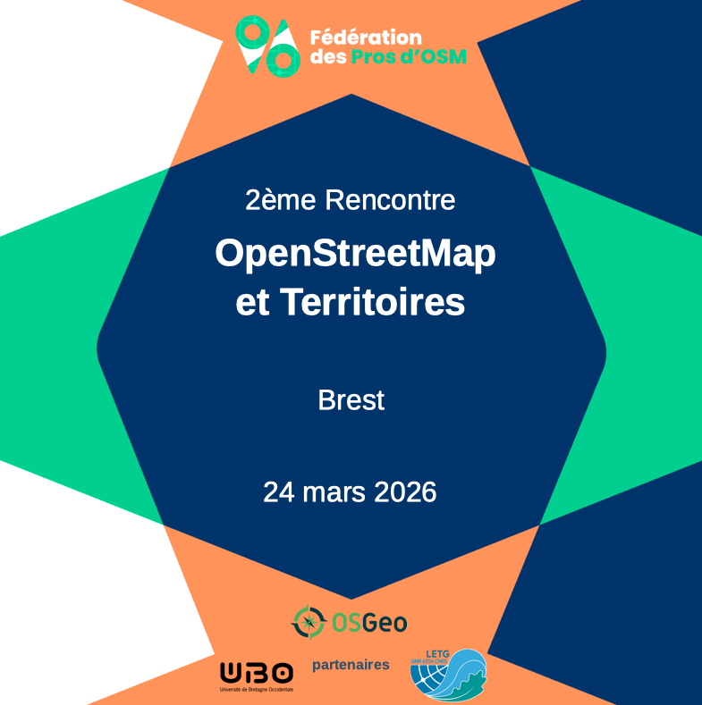
The aim of this meeting is, as you can deduce from the title, to spread the good word and to show how OpenStreetMap is used in the territories with local authorities and various local public structures. The objective is both to discuss with and have local authorities discuss with each other, especially those who have already used OpenStreetMap. It is also, we hope, to motivate other communities to integrate OpenStreetMap into their territorial projects.
So obviously, you don’t have to be a geomatician to participate in this event, or for that matter to be interested in OpenStreetMap. This meeting was designed to be composed of testimonies and practical workshops that will speak as much to geomaticians, of course, but also to political decision-makers, department directors, project managers, etc.
And really, we have planned a wide range of topics around OpenStreetMap and how OpenStreetMap is and can also be implemented in the territories, on topics such as food, map creation, humanitarian mapping, the ODbL license, the ecosystem of tools for contributing and using OpenStreetMap, data quality, etc.
So, we have planned this event for March 24 in Brest. And for information, it is backed by the days of French-speaking QGIS users and therefore organized in partnership with the OSGeo-fr, with the University of Western Brittany and with the UMR Littoral, Environment, Remote Sensing and Geomatics. Thank you very much to them.
So, at the time of the broadcast of this podcast episode, I imagine that the event will have already taken place, but today, as I speak to you, I don’t hide from you that I am very much looking forward to it and I also hope that it will be the beginning of a series of events and meetings that we will be able to organize.
Walid: For listeners who don’t know QGIS, can you explain in two words what QGIS and OSGeo are?
Florian: QGIS is the free software that is used by geomaticians, so the people who make maps and cartographic databases. It is a software that had a somewhat difficult start and is now widely used in industry, by local authorities. So, it’s a business software that allows you to use OpenStreetMap data, but all map data. And so, the fact that we rely on the people who develop and maintain this QGIS project, for us, was quite important because there are really connections that are ultra-strong.
Walid: And OSGeo, isn’t it a foundation?
Florian: It’s the foundation behind QGIS, I think. I see them from a little distance. There are other people who are more expert in the business and who are much closer to these projects than I am. But overall, in geospatial, open source and open data are gaining a lot of momentum. There are projects that are a bit like sisters, brothers, who do somewhat parallel activities.
Walid: Thank you. Let’s come back to that, after my little parenthesis, let’s go back to the different actions. Are there any other actions you want to highlight?
Marina: I also wanted to talk about the OpenStreetMap and Territory booklet that we have just published and distributed. The idea behind this booklet was to have a support that shows in a very concrete way the richness of OpenStreetMap uses in local authorities.
At the beginning, we wanted to make a one-page infographic, except that when we started working on it with the other members of the Federation, we had so many subjects to deal with and that we wanted to highlight that it became a 12-page booklet. And so, for this first edition of this booklet, and I hope there will be others as well, we have selected six subjects in particular, sites quickly: food and commerce, mobility, tourism and attractiveness, citizen participation, roads and urban planning, and GIS, geographic information system.
And we present these subjects through interviews and testimonies of people who work in communities and in public structures. For example, it can be regional natural parks, tourist offices, it can be mobility organising authorities, communities of municipalities, etc. And I think that, for once, the result is great because, of course, it’s the people who are on the ground, the people who work in the territories, who talk about OSM best and who will explain very clearly why they chose OpenStreetMap, what their context was, their considerations, what it turned out to be. And so I mention for example the Haut-Jura Regional Nature Park , which testified about the organization of map parties on its territory and the training of agents, the Pays de Lorient which highlighted the local food sector on OpenStreetMap, and then there are other testimonies from Montpellier, Sénart, Île-de-France Mobilités, etc. And so, I’m not going to spoil you any more, but it’s a small 12-page booklet. It is licensed under CC BY-SA, of course, and is now available on our website. And it also allows me to make the connection. This is our second practical guide that we have published. The first one dealt with the subject of the ODbL license, the OpenStreetMap license. And it was published by the Federation in September 2024. And I think Florian, he can’t wait to talk about it more.
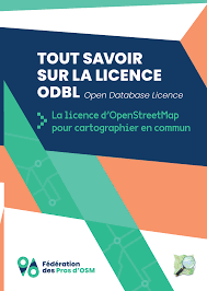
Florian: Yes, I can talk about this booklet, this explanation, this democratization of the subject of the bachelor’s degree. The legal license is always complicated, it’s law.
But OpenStreetMap, basically, is more than a map, it’s a map database. So, it’s data that we can put in a database and that we can use to make maps, to make route planners, to make wallpaper. Really, there are many examples. You can do what you want with a cartographic database and so it’s actually governed by an Open Data license like Wikipedia is governed by Creative Commons and well OpenStreetMap is the ODbL (Open Database License) which stipulates more or less the same things but rather on the right of the database because Creative Commons is more related to copyright. So we needed a dedicated license and this ODbL license is explained in this booklet: these are the rights and duties of everyone on the reuse of data. And it’s interesting to see that, like Wikipedia, the choice that has been made is the commercial use of data and by default, authorized. So, companies are welcome as contributors, but also as re-users of OpenStreetMap data. You just have to not do anything.
Florian Lainez
There are duties. And the homework is to mention the fact that the data comes from OpenStreetMap. So, if you are on the street, I invite you to look at the bottom of the maps that you see on bus shelters or on the material on the street furniture that you see in your own city, look at the bottom of the maps, at the bottom right, there are little legal notices and sometimes it says OpenStreetMap and it is more and more common. So that’s citing the source, it’s a legal obligation of the ODbL license, it should be mentioned that the data comes from OpenStreetMap. And then, the second is to donate the data to the OpenStreetMap project or to republish in Open Data under the same license if it is significantly modified and in this booklet we legally detail what this means in a significant way, there are many exceptions, companies and any reuser can use OpenStreetMap data very extensively. The constraints are quite limited but it’s interesting this obligation to republish and reshare for us, it’s something very important, interesting to see that if everyone can take data for free if you modify it, and it’s the least you can do to reshare it.
Walid : I’ll put all the links in the episode transcript in any case. Another question, so we talked earlier about the forum, I was wondering what digital tools you use to organize yourself in addition to the forum. What do you use as a tool? Can it give ideas to others, for example?
Florian : We don’t have any tools in common. Each company is free to use its own information system. We make video calls every month, we have a drive in common, we have a forum in common. It’s quite limited, in fact, what we use. We have a website that runs on WordPress.
Walid : I’m reformulating, what software do you use significantly to organize yourself and to collaborate together? I was talking more about software, that’s what interests me, to see if there are things that are common or that can give ideas to other people.
Florian : So there are two pieces of software that come to mind. The first is the historical software of the OpenStreetMap community, which is JOSM (Java OpenStreetMap Editor), which is developed in Java, which is cross-platform and allows you to contribute. It’s made to contribute to OpenStreetMap, so it allows you to use the data, but essentially it’s an editor that allows you to contribute. It is a software that has been developed over 20 years, it is extremely successful with many plugins, possibilities to do indoor, 3D, multilevel, to display very diverse and varied basemaps, to display photographic sources. It’s really very advanced. And then the second, I would say, is QGIS, which is more really related to the world of geomatics than to OpenStreetMap and which allows you to reuse the data very simply in a geomatics software that is widely used in the world of geomatics.
State of the map 2026 in Paris
Walid : I notice that in the actions, there are things that we haven’t talked about. I am thinking in particular of two things. The first is this year’s State of the Map . So I’ll let you talk about it instead, you’ll talk about it much better than me. You are focused on this: how does the Federation participate in the organization of this event?
Florian : Yes, so this year it’s very special because the State of the Map France is replaced by a State of the Map World. So it’s contributors from all over the world who will come to France this year, it’s from August 28 to 30 in Paris. And it’s an event that is organized first and foremost by the OpenStreetMap Foundation and then by the local chapter, by OpenStreetMap France. So the Federation, obviously, will be very involved through its volunteers who participate in the organization of the event, but also more directly through sponsorship. So it’s only natural for companies that rely on OpenStreetMap solutions to contribute in return to the organization of an event that allows us to exchange all this knowledge and federate the community in this event which is very important.
The federation’s advocacy actions
Walid : And the second thing you noted and on which I would like you to elaborate a little bit on this is what you noted: advocacy actions. So I’m interested in you saying a few words about this: who are you talking to? Who are the actors with whom you advocate for OpenStreetMap?
Florian : Okay. So here, I can’t name them all. By design, since each in our business, each company has its own interlocutors. There are people who are in the networks, who work with Enedis. I have never had contact with them, but there is advocacy and even collaborations that have been set up with these companies. Each in his or her own sector of activity. So, I said SNCF, Île-de-France Mobilités. We can really mention many local authorities. What interests us is to be in contact with all the actors, all these actors of society who can support and contribute to OpenStreetMap. So, we will see them where possible in the interest of our companies and in the interest of the OpenStreetMap project. So, we often share stands, so the financing costs, quite simply. We share the financing costs and the presence of stands at trade shows. We are doing it more and more. So that’s very good news and it’s really proof of the vitality of the federation, to show that we are present in working groups, in trade fairs, in professional working groups.
Walid : Marina, do you want to add anything?
Marina : yes,
Also when we see that there are webinars that are organized by institutions, by public actors and that are on our core business, we will always participate in them and we will also participate with the OpenStreetMap Federation of Pros hat and therefore ask questions about OpenStreetMap, do advocacy, especially when we see that we are going to deal with subjects without talking about OpenStreetMap where, in fact, OpenStreetMap is supposed to be a must-have. So there is also this work of online presence, also of presence with institutional actors to remind people of the existence, the interests, the benefits, the applications of OpenStreetMap so that it is not forgotten in the discussions.
Marina Petkova
Walid : I realize, because you said, Florian, to share the costs for the stands, I realize that I forgot to ask you both a question, which is: to be a member of the OpenStreetMap federation of pros. So, what is it? Is it paying a membership fee? Basically, what does it entail in financial terms?
Florian : Yes, there is an annual fee that is paid. So, we think it’s very important to support small structures, especially those that are being set up, that are setting up business projects. That’s why for self-employed people, it’s 60 euros. The membership fee is very low for the year. And then, in terms of the number of employees, it increases so that the biggest structures provide the majority of the budget, so that everything is very balanced. And with this overall budget, which is quite limited, in the end, we manage to organize events. And it’s beyond this basic budget that we manage to coordinate to book trade fairs, to hold conferences. That’s really beyond this basic contribution.
Marina : ok. Yes, I also wanted to add in relation to advocacy, there is a complementary axis. I hope it won’t seem irrelevant, but it’s also in the federation’s advocacy and communication.
There is of course the communication around OpenStreetMap, but there is also the promotion of the skills of the members and the work already carried out by the federation. So that’s part of it. The objective is certainly to raise awareness of OpenStreetMap, but also to show all the skills that already exist on French soil, that are available to local authorities and companies, that are held by our members. And then also try to promote the existing tools that are developed by the community or by the members of the Federation, as long as they are in the OpenStreetMap ecosystem. It is always better to enhance the existing than to reinvent the wheel. So there is also an advocacy axis around this.
Marina Petkova
Walid : I may say something, maybe something stupid, but there are OpenStreetMap certifications? Because in fact, typically, as in many places, being able to prove your competence in professional terms is something important. I wonder if it exists.
Florian : The subject is, I think, on two levels. The first is that of vocational training. So we have a member, 2i2l, not to mention him, which offers training, particularly related to OpenStreetMap, which is carried out to increase skills on these subjects. There is no OpenStreetMap certification. Neither the Foundation nor the Federation really have the vocation to do this kind of certification. And then, on the education side, as long as we are in the subject, we have an obligation for high school students to be trained in OpenStreetMap for many years in progress… So, for me, it was called techno. What is it called today? I forgot the name.
Marina: The PIX, I have the impression.
Florian : the ?
Marina: In the PIX module, right?
Florian: The PIX module, surely. it turns out, it has changed…
Walid: But is there an obligation to train OpenStreetMap?
Florian: yes,
it was passed many, many years ago and we now see people arriving in the OpenStreetMap community who said “I discovered OpenStreetMap in high school”. And that’s really interesting. Not only have we seen them arrive in the community, it’s been a long time, but now they’re part of the board of directors of OpenStreetMap France. So, we can see that they have grown up. They were interested in the subject and so that’s really something very promising.
Florian Lainez
And so, I have the impression that also, on the professional side, we have a bit of this mission to move towards higher education training and to try to explain to future geomaticians how to contribute to the digital commons, why it is important and how we do it. And there are some of us who take this mission quite seriously, who go to higher institutions to train students.
Collaboration and coopetition within the federation
Walid: I’d like us to talk about a subject on which, for once, I have a lot of questions too, it’s cooperation within the federation. So there, in fact, we have companies which, from what I understand, have skills that are often or sometimes or often complementary, but sometimes that will also compete for markets. What do these companies collaborate on and what are they competing on? That’s really a subject that I find really interesting to talk about. Marina, you wanted to speak. I’ll let you speak.
Marina: Indeed, we do not refrain from competing with each other on markets or even when we talk by mutual agreement, that is to say that everyone is free to submit a proposal on their own, even if we know that we will have our colleagues who are members of the Federation. That being said, in many markets, we still tend to form a group, to get together because we will be stronger together, we will be more complementary, we will have a strike force, if I may say so, greater than if we start on our own, especially since for many of us, We are very small structures.
So, when we talk about a market worth several tens of thousands of euros, a very small structure of people, it will be difficult to convince the client on its own. So, it’s in our best interest to get together. And this is also true when applying for calls for projects or calls for expressions of interest. When we go to present a project, it’s often a project around OpenStreetMap, but when we go to present a project together, we have all the more chances of being selected because, precisely, we play the card of complementary skills.
Walid: And then, for example, if you respond to several people on a project, is it co-contracting? There is one that is a bit of a hat and that subcontracts to the others. How does it work? Is it quite variable?
Florian: Yes, it varies quite a bit. Conventional commercial law applies. So, we make our arrangements according to the project.
Walid: Within the federation, you all have an interest in making OpenStreetMap known because in the end, the more it is known, the more business it makes for you. Do you provide feedback within the federation? Do you consult according to certain calls for tenders? Is there collaboration around these pre-sales phases, for example?
Florian: We share a lot. Every month, we share. So, there is no obligation to share, but we have a habit and an advanced practice of sharing information on the files we have in progress, on which we want to respond, and what we want to respond to together. Overall, we’re more between gentlemen, I have the impression, but gentlemen also in it, but we’re very fair play between us. It’s a world that is, I think, very collaborative, not only in name but also in practice and that helps us a lot. So we work a lot in a network. When you win contracts, you can subcontract other members even after you have won the contract. It really happens all the time, it’s very often.
Walid: Do you ever give feedback from public experiences, for example?
Florian: On our website, we put some references on the fposm.fr federation’s website. There are references that explain a little of the past projects that have been carried out and that give axes of reflection on the future, on what services can exist, what we can be asked to do.
Marina: And in terms of feedback, what we’re also going to do is that we’re working on a mission and we’re led to develop a tool or strengthen a tool that already exists in the OpenStreetMap ecosystem, we’re going to call on all members to use this tool, to capitalize on what’s already existing and on the work that has been done. And in terms of feedback too, I think it’s excellent because for many of us, our work can be freely communicated on some major topics around OpenStreetMap. The feedback will feed even more into the reflections we can have around one of the economic models and the possible services and benefits and tools around OpenStreetMap, but also we will be able to communicate with the community and see what can be further developed.
Florian: I spoke earlier about the State of the Map France, this annual meeting of OpenStreetMap contributors in France, it’s a place where many conferences are given either by companies or directly by customers. There are local authorities either they are clients of members of the Federation or they carry out projects on their own. Local authorities did not wait for companies to take hold of OpenStreetMap. On these State of the Maps, there are many conferences by professional actors who come there on behalf of the institution they represent to present very advanced projects of data creation, data maintenance, creation of digital services that are linked to this OpenStreetMap data.
Walid: I’ll also put in the transcript the link to the PeerTube server of the OpenStreetMap France association on which there are lots of super interesting conferences. Yes, Marina, did you want to add something?
Marina: On the issue of feedback, it is in our best interest to communicate as openly as possible because one of the challenges of the Federation is also to make local authority agents and companies want to use OpenStreetMap. And in fact, firstly, it’s a long-term job and secondly, we have to show concrete projects to create this desire among local authorities, especially those who don’t necessarily know OpenStreetMap or who are a little hesitant, etc. It is in our best interest to give a lot of feedback and to communicate openly about our skills, of course, but especially about our concrete projects.
The challenges of the federation in the months and years to come
Walid: Thank you Marina. You’ve just transitioned to the last big part I wanted to touch on, which was the challenges for OpenStreetMap. So there’s one you just talked about. I wanted us to continue on the challenges of OpenStreetMap. Can you tell me more about what awaits you? What are the major challenges that lie ahead for you in the months and years to come?
Marina: It’s really the promotion and advocacy, the defense of the digital commons that is OpenStreetMap. I have the impression that it is played out on several levels, that is to say that we have a political level, we have a business level, we have a business level. We talked about this a little earlier, but for example, at the political level, there are questions that are more of a legislator’s nature on issues of open data, on the structuring of the commons, on the framework for the legal protection of the commons. There, there is a huge plea to be made that is very complicated to navigate and that also escapes us a little. At the business level, as I have just said, for local authorities, you have to give them the desire. We need to make OpenStreetMap known, yes, but we also need to make people want to make projects and to know that we can… We’re not alone, actually.
When you do OpenStreetMap projects, you’re never alone. Whether you call on a company or not, there is always the volunteer community that is there, there is always the wiki, there are always enormous, enormous resources, but you have to give the desire. And then, at the business level, we need to train new economic players so that they understand the ecosystem around OpenStreetMap as well as possible and so that they know how to integrate themselves in good intelligence into this ecosystem, whether it’s the community, whether it’s the rules, the license, everything that is… How do we contribute, how do we use OpenStreetMap correctly.
Walid: On these advocacy issues, I’ll come back to that for two seconds. Do you support yourself or are you in collaboration with other free software associations that work on these advocacy issues? I think in particular, we talked about it several times on the podcast, for example associations like April, which are used to talking to communities, governments, etc. Are you, on these advocacy actions, in partnership with other associations, other people who will help you spread the good word?
Florian: Our federation has now been structured for a few years around a few companies that had a common desire and values, a desire to do the same thing and common values. Now, we have to go further. And indeed, this is the moment, I think, when we will be able to open up. That said, there are some of us, I’m thinking in particular of Jean-Christophe Bécquet, who is the vice-president of the federation, who is an administrator of April. So, the world is small. We know the players in the ecosystem well, all these associations in particular. We know the companies that have been making free software for decades. In open data, it’s the same, we know the players very well, some of us are even part of it. So we are now calling for the creation of bridges. We don’t have any prejudices about how this can be done, but indeed, I think that there are very important bridges that will have to be created in the years to come.
Walid: Do you have any challenges? Because there, we talked a lot about advocacy, rather externally, but do you have any internal challenges, of internal structuring of the federation in the months to come? Are there things that stand out? You know, you’re going to have to work on it in the future.
Florian:
Yes, lately, the questions we’ve been asking ourselves are whether this new member who is asking to join the federation, do we feel that he/she will respect the ethical charter? And these are questions that we didn’t ask ourselves at the beginning, since we were among ourselves, between motivated and interested people, and we had no, we never had any doubt about the first actors, about their sincerity to join us. Today, we see that there are players who are not from the OpenStreetMap world who are interested in it and we are very open to it, we are very happy that this is the case, that it is happening. And now, we have this problem, this growth challenge to know where we define red lines. Will groups that are only interested in OpenStreetMap out of interest, say no?
Florian Lainez
And those we already know and who are very invested, we already know them, they are already members of the federation. So now, there are still intermediate cases where it’s difficult to judge, to agree. And that’s what’s interesting and that’s what awaits us in the years to come.
Marina: I also think that there is, in addition to what Florian has just said, a communication challenge. Communication in the sense that how internally, but also externally, we manage to value everything that the Federation has already done. How do we manage to enhance the skills of members? And that’s communication, that’s communication. It’s a long-term job. It’s not always easy and easy to do so, but we’re going to have to organize ourselves better internally so that we have more presence externally as well.
Walid: I have one last question that is a bit subsidiary before moving on to the conclusion. Before the arrival of the federation of OSM pros, there were already actors who were doing advocacy and talking to administrations, communities, etc. There, there is the federation that arrives, that has a grouping, that speaks with one voice. How do the interlocutors in the communities or even within the government, I don’t know if you have any relations with them, how do they see the arrival of these new players? Is it an additional player? Is it a chance to have an actor who speaks for many companies? Does it add an additional player? How is it organized in relation to the people who were already there before?
Florian: For their part, the local authorities, in fact, did not wait for us to get organized. In France, there is an association called Open Data France, which has only local authorities as members and which does open data. There is indeed BetaGouv, there are government programs that have been set up to make open data, open source, to bring them into the administration. They are already well advanced.
Now, how were we seen, how was our arrival seen? I have the impression that people didn’t realize. It’s complicated to realize that there is a federation when there is an OpenStreetMap foundation and there is an OpenStreetMap France association and now there is a federation. It’s a bit complicated, it’s a little difficult to read. So I think that the main interest of the federation’s existence is not in the fact of existing, it’s really in the actions we take. So in the creation of our booklets, the support of all the actors in everything we are going to do. The federation itself, in the end, is of little importance to those who are outside. You don’t have to lift the crowds.
Conclusion
Walid: ok. Listen, we’re going to get to the end of the interview. We’ve already been talking for 1 hour and 20 minutes. By way of conclusion, and before I leave you with a final word, I would have liked to ask you a few very quick questions. The first was what would you say to a company, a community that doesn’t yet know the OpenStreetMap federation of pros?
Marina: Maybe you’re starting to get interested in OpenStreetMap, but you’re not sure how to go about it or if it’s relevant to your projects. In this case, the OpenStreetMap federation of pros can help you clarify your project and put you in touch with people whose job it is. Then, if you know a little better your needs and desires, you will find within the Federation all the diversity of skills that allows you to bring a project around OpenStreetMap to life from A to Z.
Walid: Florian, are you going to add anything?
Florian: I have a complementary message for those OpenStreetMap contributors who want to set up a company related to OpenStreetMap and who don’t know where to start: come and talk to us. We’ve been there and we have ideas and marbles to support you, to structure your entrepreneurial project and help you set up this company.
Walid: Well, you answered my second question which was, what would you say to OSM contributors, who don’t know, to introduce the federation. Did you pretty much answer that?
Florian: It’s not exactly that, because it was aimed at people who want to make it their profession.
Walid: More generally.
Florian: And yes, it’s true that OpenStreetMap contributors, there are many who are volunteers and who see that there is a complementary work with companies.
My message to these people is that with our companies, we can afford to free up time and resources to create tools and to support you, to help you in the projects you carry out on a voluntary basis. I’m not saying this in vain, since I myself am a volunteer and I spend my weekends and nights contributing to OpenStreetMap. And so, during the day, when I meet my clients’ needs, I try to develop tools that also allow contributors to move forward and be more efficient. So, all this is a small world that is quite complementary. So, my quick message, it would be we have complementary activities, it’s good continuing to move forward together.
Walid: My last question, what would you say to people or companies, well, companies that would like to join you?
Marina: Let’s have a good time, let’s discuss it and above all tell us about your skills, your projects, your desires and especially your past or future commitments around OpenStreetMap. We are open to discussion, we will be happy to exchange with you.
Walid: Perfect. So now, I’ll leave you both with a final word. If you have something, an idea, a desire, something to convey as a message before you leave, I’ll let you speak. Marina, do you want to start for a final word?
Marina: So me,
I wanted to quote my favorite sentence from our OpenStreetMap and Territory guide, which comes from a testimonial and says “With OpenStreetMap, you don’t start from scratch”. And in fact, to all communities and companies, I want to say “make OpenStreetMap, already”. You will be surprised by the richness of this common. Even if you think you see more or less what it is, I assure you that you will be surprised at the enormous potential of OpenStreetMap and you will be surprised at all the work that has already been done thanks to more than 20 years of contribution. So first, do OpenStreetMap, then do it correctly while respecting this work already done, the community, the rules, the license. Do this by cooperating with contributors and software publishers around OpenStreetMap and above all promote the existing. I promise you that it’s absolutely extraordinary what is already done with OpenStreetMap and how much we can do with it. Thank you.
Marina Petkova
Walid: Florian, your last word?
Florian: For the last word, I think I’ll talk about OpenStreetMap in two parts. The first is simply a cartographic database, so data, maps that can be used and that is a technical solution that works. And that, we’ve proven many times on multiple subjects, that it’s a database. In fact, it’s something that works and really works.
And as Marina said, we’re not starting from scratch and there are already things that are advanced, which are very, very far in the way forward. I think that the work, the tools in fact of the OpenStreetMap community, it would really give cold sweats to many people who work in companies that work on the CAC 40 and who would see how far we are advanced in our reflections and in our work. It’s absolutely phenomenal and it’s very often underestimated. This is the first part.
And the second, the OpenStreetMap community, is more about the community, it’s how we organize ourselves to create things. And I have the impression that we are at a point, at a time when open data, in fact, we have reached the end of the concept of open data, of publishing data for the sake of publishing data and then doing nothing with it. I hope that there are many private or public actors, but mainly public ones, who will take the measure of the change that is necessary to move from open data, from publication for legal reasons, to follow the law, to the creation of communities and digital commons that will really be the vectors for bringing new benefits that are very often underestimated. There are a lot of decision-makers who make decisions along the lines of “well, I’m going to make my database in-house and then we’re going to put a full-time person to maintain it and then it’s going to work.”
Florian Lainez
In a new approach, we could do this with OpenStreetMap. And you didn’t remove the resources because it takes resources to create, to maintain data in OpenStreetMap, but these are resources that sometimes require you to animate the community, to talk with the community, in short, to co-create rather than creating everyone in their silo. And so there you have it, my message is a bit let’s get out of this somewhat flat dynamic of publishing open data, a much more interesting and enriching dynamic of co-creation of the commons that can at first glance be difficult to get into it. And we have created a lot of communication channels, including the Federation and professionals, to inspire, explain, support on all technical, legal, human and organizational issues to succeed in making projects with the community.
Walid: Thank you both. It was super interesting. We will certainly continue to talk about OpenStreetMap in the coming months since I actually wanted to talk about Panoramax, but I thought that first it would be good to talk about the federation of OpenStreetMap pros. We’ll talk about all this again in the coming months. For the listeners of the podcast, well as usual, share it around you, in your entourage, in communities and voila, take an interest in what the OpenStreetMap federation of pros does. Marina, Florian, thank you, see you soon.
Florian: thank you for this invitation. Goodbye.
Walid: goodbye.
Episode production
- Remote check-in on March 9, 2026
- Plot: Walid Nouh, thanks to Alex Bourreau
- Editing: Walid Nouh
- Transcript: Walid Nouh
This interview has been automatically translated from the original language into English.
License
This podcast is released under the CC BY-SA 4.0 license or later